Khodjeyli District is a district of the Republic of Karakalpakstan. It was established on January 14, 1926. It is located on the left bank of the Amu Darya River. It borders Nukus to the north, Karaozak to the southeast, Kanlikol, and Shumanay districts to the northwest, and the Old Urgench district of Turkmenistan to the west and south. The area is 0.85 thousand km². The population is 146.4 thousand people (2004). The district has 9 aul citizens' assemblies (Amu Darya, Begjap, Janajap, Kenagas, Kulob, Naymankul, Saraykul, Sarichunkul, Somonkul), 1 city (Khojaly), and 1 town (Vodnik). The center is the city of Khojaly.
Nature
The relief is mainly flat. The terrain is sharply continental. The average annual temperature is 11°C, the average January temperature is –6.9°C, the lowest temperature is –32°C. The average July temperature is 27.1°, the highest temperature is 44°C. The vegetation period is 196 days. 120 mm of precipitation falls annually. The Kun'gorat and other canals flow through the district. The plants include reeds, reeds, bulrushes, dogwood, sedge, wheatgrass, ajriq, korabaroq, aqbosh, pine, yulgun, turangil, wild zhiyda, willow, selin, etc. The wild animals are mainly rodents and reptiles; The birds include ducks, geese, swans, coots, mergansers, terns, terns, stilts, wagtails, sedge warblers, sedge warblers, sedge warblers, sedge warblers, and others. The soils are mainly sandy desert soils. Stone used in foundations is mined from minerals (Sarychunkul, Naymankul).
Population
The population is mainly Karakalpaks and Uzbeks, as well as Kazakhs, Turkmens, Russians, Tatars, Koreans, and representatives of other nationalities. The average population density is 172 people per km² (2004).
Economy
The district has 10 industrial enterprises (including flour and cereal, rice, mixed feed plants, etc.), 4 automobile enterprises, a post office, electrical communication enterprises, railway transport, gas pipelines (compressors that deliver gas to the central regions of the Russian Federation and the Urals), a sewing factory, a carpet factory, and other activities.
Currently, the district has 26 open joint-stock companies, 24 limited liability public enterprises, more than 90 trade departments, pharmacies, private small and individual enterprises, the number of firms has reached 676 hectares[2].
The main branch of agriculture is cotton growing. Grain, vegetables and melons, potatoes, rice, and fodder crops are also grown. There are 11 companies, 5 farm associations, and 490 dehkan farms. 329 farms in the district are engaged in agriculture, 69 in animal husbandry, and 16 in gardening. Agricultural crops are planted on 22.5 thousand hectares of land in the district. In collective and private farms in the Khojaly district, cattle, sheep and goats, horses, and poultry are raised. Silkworm breeding is also practiced.
There are 72 general education schools, 2 special boarding schools, an orphanage, and 4 vocational guidance centers for students in the district.
9 houses of culture, 3 clubs, a folk theater, a culture and recreation park, and 35 libraries serve the population. There are 3 hospitals, 5 polyclinics, 2 dispensaries, 10 rural medical stations, 4 rural medical outpatient clinics, 14 feldsher obstetric stations, and an emergency medical service.
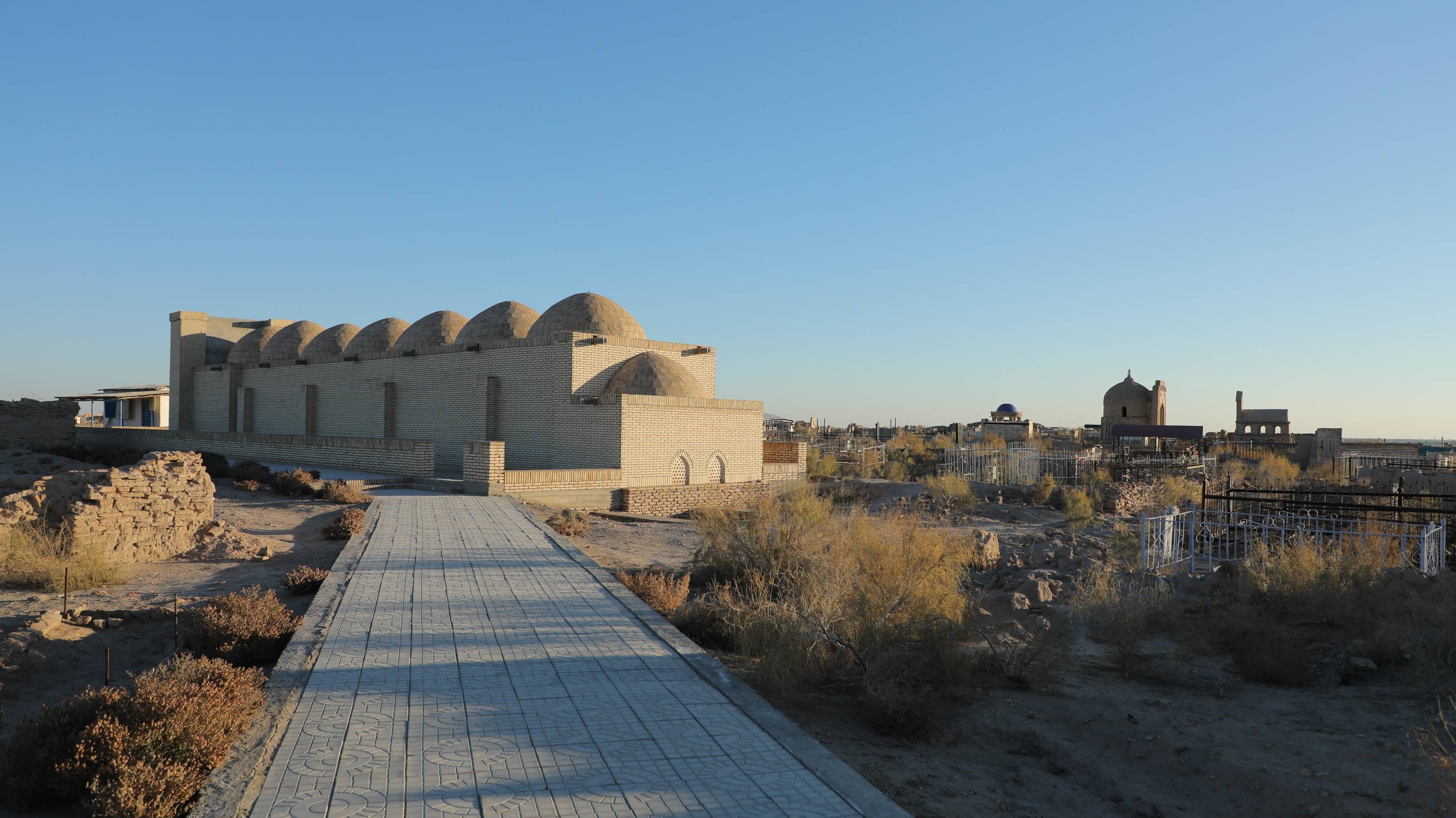
Among the historical and architectural monuments, the ruins of the medieval city of Mizdakkhan, the Gabr fortress hill, the Jumard hill, the Antakya city hill (14th century), the Mazlumkhan Suluv mausoleum (late 13th - early 14th centuries), the Shamun Nabi mausoleum, the Rajab Khalifa house, and the Forty Shepherds monument are preserved on its territory.